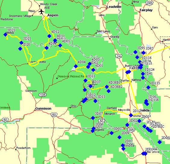
Overview Route Map
This map shows all of the waypoints loaded into the GPS receivers and a track log (yellow) of our route from vehicle parking (outside of Buena Vista) to Crested Butte via Aspen (Taylor and Pearl Pass). Also tracks are shown for some of Thursday's ride to Marble and Fridays return via Tin Cup Pass.
To use, move the curser over the area of interest and note the change in the url's appearing in your browser's status bar. Left click to see the detail Topo. These are maps are from Garmin's MapSource Topo data. Many of the road numbers, place names, etc are incorrect probably due to using OCR software to scan the original USGS topos with no human checking! However, the graphical info seems accurate for the most part.
Note, if you right click on one of the hotspots you can select "open link in new window" which is useful if you want to look at several detail maps at once.
The table below shows the Topo maps that are linked via hot spots on the over view map above. The maps with profiles is based on altitude data from Jamie's eTrex GPS. The Garmin III does not record Altitude data (I should hope that the "soon to be released" Garmin IV, will!)
|
Linked Topo Maps |
Comments |
| D1.htm | Salida/BV loop showing the return track to Salida |
| D2.htm | Rainbow trail and Jim/Steve return to Salida. Rainbow trail Profile |
| D3a.htm | Aborted Napolean Pass route. Note missed L turn along creek |
| D3J2.htm | Day 3 A team route. Profile from Marshall Pass to Tincup |
| D3J3b.htm | Timber Line trail on Day 6 |
| D3J3a.htm | A team on single track and Cement Creek rd |
| D6.htm | Day 4 and Day 5 tracks, inc BV/Aspen/CB via Pearl Pass |